A half-day walk (2-3 hours, 4-5 miles) visiting Prior Park Landscape Garden on foot from the city centre, via footpaths offering a variety of natural scenery and some of the best views over Bath
Map of walk (Ordnance Survey)
This walk starts and finishes at Bath’s railway station, though at the end I’ve added an alternative ending which heads through the Georgian streets to Pulteney Bridge. It heads uphill from Widcombe taking a shady footpath and brings you to the entrance of Prior Park Landscape Garden (paid admission, free to National Trust members). The route includes a visit to the gardens and then another short uphill through fields before joining a stretch of the National Trust’s Bath Skyline trail (in my opinion, the best stretch). After some of the finest views of the city, my circular walk then brings you back down into Bath and along a canalside path back to Widcombe.
The aim of the walk is to take you a scenic way to the gardens, and in the space of one short-ish walk from central Bath, give the walker a variety of landscapes and terrains to experience, as wall as a taste of the local history and a city panorama. If you’re on a short break, it could be a refreshing escape from the city streets into nature, all on foot and without covering too much distance.
The walk is an easy one, but with quite a lot of ups and downs, including a sustained uphill to reach Prior Park and another within the landscape garden itself. There are steps at several points in the walk. In winter, be prepared for part of the route to be wet and muddy, and there is some rough surface, so I’d recommend good walking shoes or boots.
Check that Prior Park Gardens are open – times vary during the year and it’s generally only opened at weekends in winter – and that you will arrive in time for last admission, which is usually an hour before closing (National Trust page). After the initial Widcombe stretch, the only refreshment stop directly on the route is within the gardens, where there is a Tea Cabin – again, check the site’s website to see if this is open. Take water for the walk. In hot summer weather the uphill is easier thanks to being mostly in the shade.
At the foot of this page I’ve included alternative options for when the gardens are closed, or for walkers who’d like to follow the walking route without the garden visit. These options require a short stretch of road walking.
Walk part 1: Bath Spa railway station – Widcombe – Pope’s Walk – Prior Park Landscape Garden
From the open square lined with restaurants alongside Bath’s railway station, head under the open railway arch (between a bike shop and Franco Manca). Once under the railway, head left to cross the pedestrian bridge across the river. This crossing of the Avon is called the Halfpenny (‘Ha’penny’) Bridge, as this was at one time the toll to cross it. It replaced an earlier bridge which collapsed when hundreds of people were crossing it to go to the Bath and West Show in 1877; 8 died. The bridge’s toll house (1862) is an interesting original feature. This stretch of river used to cause big flooding problems for Bath; even now the levels in the river can get very high at times, and the toll house is at risk; I’ve seen water halfway up one of its windows. Flood levels are marked on the building with dates.
Once across the bridge, turn left and walk a few yards to a pedestrian crossing, cross the road then walk up and around to the left to Widcombe Parade, a charming little high street of shops, cafés and pubs. There are good places to eat and drink here, including the excellent Widcombe Deli at the Ram. At the far end, cross the road and turn up Prior Park Road, the first right.
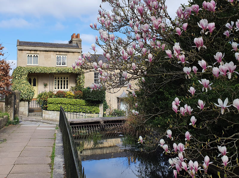
After the first row of terraced cottages, take a short scenic detour starting up the steep cobbled lane on the right, Prior Park Cottages. After a few yards take the paved pedestrian route on your left, which continues above Prior Park Road between a terrace of fine Georgian buildings and a small stream. As you start along this picturesque walkway, look back to admire the unusual and charming Gothic-windowed cottage behind you, called ‘Good Hope’ – this view is one of my favourites in Widcombe.
At the end of this promenade, rejoin the pavement on Prior Park Road and continue up the road as it begins to climb and bend around. You’ll pass Prior Park Garden Centre where there is a food shop and a café. Ignore the first road on the right, and take the second, Perrymead, which turns off just before the entrance to Bath Abbey cemetery. As Bath was supposed to be a health resort, it was decided that burials should be discreetly away from the city centre to avoid discouragement for health tourists. The cemetery is an interesting place to explore.
A bit more history just before you turn into Perrymead: the building ahead on the other side of Prior Park Road is one of the lodges of Ralph Allen’s house, Prior Park. The road up the hill is called Ralph Allen’s Drive. One of the most important figures of Bath history, Ralph Allen developed stone mines at the top of the hill in Combe Down. A trackway here brought the stone down into Bath to a riverside wharf, for transport and for construction of the Georgian city. He built his own mansion near the top of the hill, with its gardens and pleasure grounds extending over the hillside.
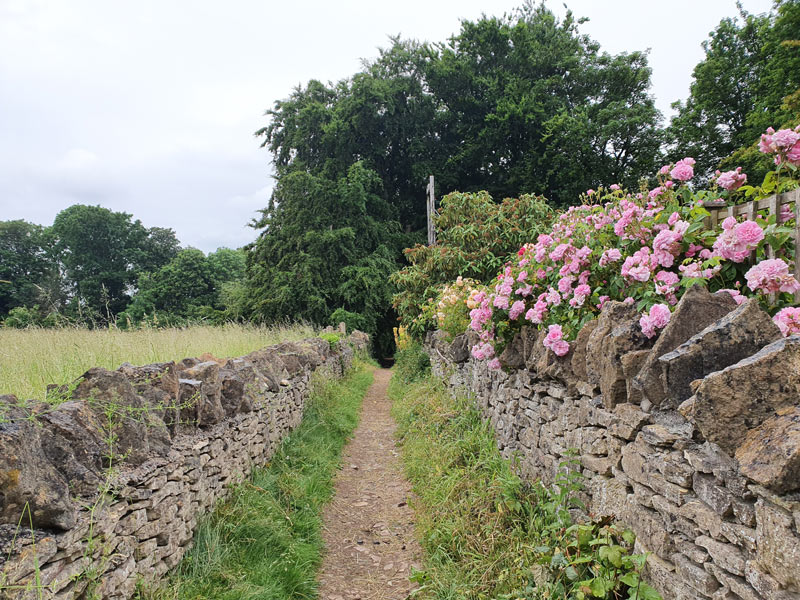
Walk up Perrymead, past some fine 18th and 19th-century villas, until you reach the LH turning up Pope’s Walk. This lane, which lacks signage, lies next to an arched gateway and lodge and climbs uphill past Bath’s Catholic Cemetery. From here the lane turns into a footpath, running through trees and between fields – visitors may be surprised to find real countryside and farmland surviving – for now – so close to the city centre. This path is an old route linking the hilltop village of Combe Down with the city, and it’s called Pope’s Walk after an association with the writer Alexander Pope, who visited Ralph Allen and advised him on his landscape gardens.

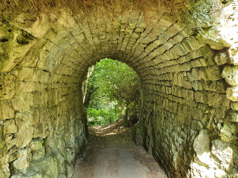
Continue upwards until you pass under a fabulous rustic bridge (more like a tunnel). This would have carried one of the ‘rides’ from Prior Park out through Ralph Allen’s pleasure grounds and the surrounding estate. Shortly after this historic feature, take an alley on the left, with a fence one side and hedge the other, to emerge into a suburban street, Priory Close. Walk up the street and then turn to the left to head down onto Ralph Allen’s Drive. When you reach the main road, you can see the grand entrance to Prior Park, Ralph Allen’s house, to the right. This is now a private school. The entrance to the National Trust gardens is a short way down the road from here, so cross with care and descend until you reach a stone gateway at the entrance to the gardens.
Walk part 2: Prior Park – Bath Skyline – Widcombe Hill – Bathwick Hill – Kennet and Avon Canal
This walking route takes you into Prior Park Landscape Garden (National Trust), where you’re free to explore, then out of the gardens either through a footpath exit on the opposite side by the summerhouse, or from a lower exit by the toilets and tea cabin. I’ve included these two alternative routes for linking the garden with the Skyline trail beyond, as sometimes one or other of the secondary exits may be closed. You could check this with staff at the entrance, who should be able to give you any directions you need as you plan your tour around the gardens. Don’t miss the watercourse at the top of the slope, just below and beyond the ticket office, the cascade below it or the grotto above the entrance (if open).
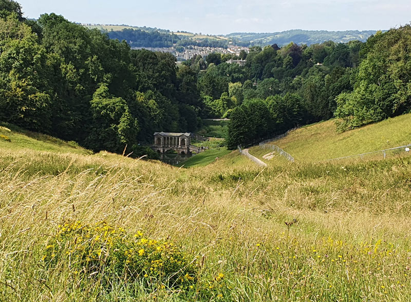
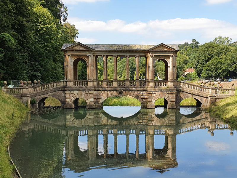
For the purpose of this walk, though it’s not really important which way you explore, I’d suggest starting a garden tour by contouring from just below the ticket office around the top of the slopes, with a fine view of Ralph Allen’s Palladian mansion above you, and a glorious view down across the sloping meadow to the ornamental lakes and famous Palladian bridge below. A businessman, Ralph Allen built the house in its conspicuous position partly as an advertisement for the Bath stone from his quarries nearby.
Beyond the short ‘canal’, take a flight of steps down to the foot of the cascade. Depending on what parts of the garden are open, you could drop down to the lakes through a woodland path to the left, or down the central meadow (which has great views).
Option 1: Footpath exit by summerhouse. After seeing the picturesque bridge, finding the hidden ice house and admiring the lakes at the bottom, it’s time to climb uphill again, taking the woodland path on the far side of the meadow. Head through a pretty woodland to the summerhouse.
Leaving the garden through a gateway on the Priory Path just past the summerhouse, head through a meadow to a viewpoint with information boards detailing the sights you can see. From here, instead of following the path around and downhill, turn your back on the sign and climb uphill. This fainter path leads up across grassland to another panoramic spot near a dead fallen tree, and joins the NT’s Skyline Walk. Head through the gate to join a shady path contouring left beside the railings, with views downhill and across to the picturesque Rainbow Wood House.

Option 2: Lower exit by tea cabin and toilets. This exit, a green foot gate next to a larger double gate, opens at the top of a lane leading into Bath. Opposite you is the entrance to a field along with an information board about the Skyline Walk. Head through the kissing gate (note there might be cattle in this field) and walk up the path ahead. This climbs through the field, where birds of prey often circle overhead, to another gate not far from the picturesque Rainbow Wood House. Once through the upper gate you’ve joined the Skyline Walk; your route leads left and upwards.
Continuing the walk. Follow the path as it climbs up a flight of steps, and head left following Skyline Walk signs. Where the path splits at an open field, you can take any branch; they meet up at the far side of the field where the route heads through a narrow gateway. Keep to the left along a field edge beyond, then turn left onto a narrow path signposted as part of the Skyline Walk. From here the wayfinding should be easy, following the National Trust’s signs.
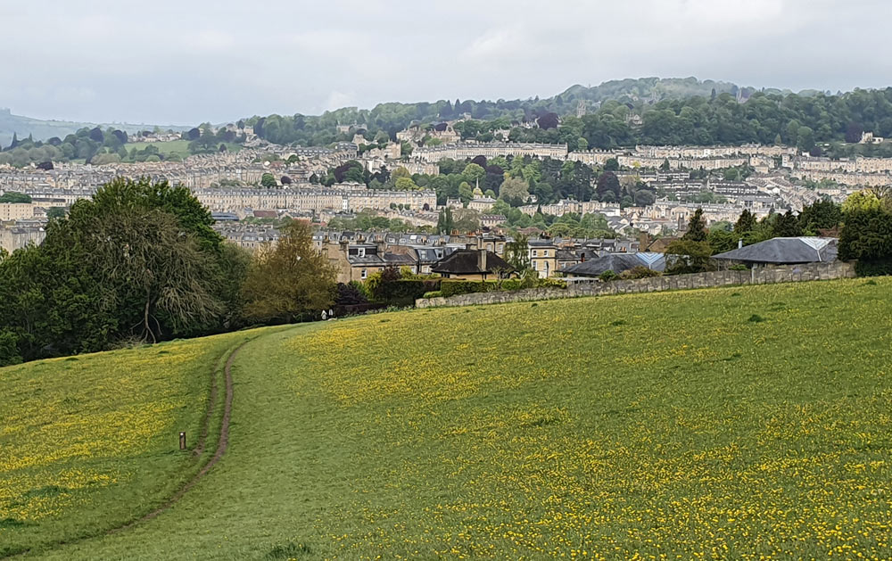
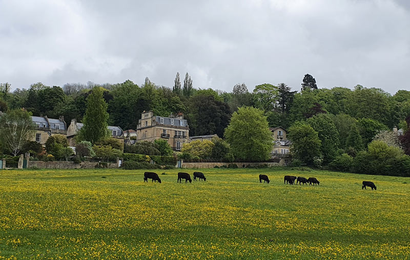
This path descends through trees to Widcombe Hill, where a row of enviable houses enjoys a fine view across fields and over the city. Cross the road. A short way down the hill, the footpath branches off down the fields, before looping down to the bottom of the valley by Smallcombe Farm and Smallcombe Cemetery. The footpath continues ahead, up the other side of the valley and emerges into one of the finest spaces around the city: open fields (sometimes grazed by cattle) with glorious views over Bath, the elegant houses of Bathwick Hill ahead, and seas of buttercups if you visit at the right time of year.

Paths popular with dog-walkers head in a number of directions across the fields; we follow the Skyline Walk through a series of gateways, with an orchard on the left, onto a long sloping field. There’s a bench by a hedge on the right if you fancy a break.
At this point we leave the signposted Skyline route, aiming instead for the bottom, farthest corner of the long meadow, keeping the Bathwick Hill houses and gardens on our right. Take the path/alleyway heading downhill, cross Sydney Gardens (a street) and continue straight downhill. You’ll find yourself on a footbridge crossing the Kennet and Avon Canal, near the top of the Widcombe flight of locks.

Once on the canal towpath, you have a choice. This walking route was designed as circular, and if you turn left you will complete the loop, following the canal into Widcombe. Where it joins the river Avon, turn left along a short stretch of pavement to return to the railway station via the Halfpenny Bridge.
As an alternative ending, if you turn right along the towpath you can follow the scenic canalside to Bathwick Hill, or continue to Sydney Gardens, an attractive historic park by the Holburne Museum. These canalside scenes are views of Bath that many visitors never see. Leaving the canal at Sydney Gardens you can walk back into central Bath along Great Pulteney Street and across Pulteney Bridge.
And next…
Enjoyed this walk? As you can imagine, it takes quite a bit of work creating and checking walks and maintaining this website. If you’re glad this is online and would like to help me keep it that way, please consider buying me a coffee, aka making a small donation. Thank you!
Walk mapping
- OS Maps: Map of walk – if you are an OS Maps subscriber (highly recommended) you can see this walk in full detail, ideal for navigating. Non-subscribers can use the free version, with the options of a basic map or an aerial view, which I wouldn’t normally advise for wayfinding, but should be enough to give a good idea of this route; a fairly straightforward circuit.
- Google Maps version – again, I wouldn’t recommend Google Maps for country walks, as the relevant detail is lacking, though it’s great for towns. However it will help to give an idea of this particular walk.
What if Prior Park Landscape Garden is closed, or we want to skip a garden visit?
I’ve created this circular route for visitors to the National Trust garden. If the garden is closed, I’d suggest skipping the first half of the walk, and instead beginning with a walk up Widcombe Hill. Turn right along Widcombe Crescent and climb the steps at the far end up to Church Street. Walk up this long lane and then Church Lane, take a footpath on the left straight up the hillside aiming to the right of Rainbow Wood House, and join the Skyline Walk at the foot of the flight of steps on the panoramic path.
If you get to the garden entrance and find it closed, or you’re unable to use the footpath exits from the gardens, you can still continue and complete the walk, but it requires some road walking. From the main gate of the garden, follow Ralph Allen’s Drive uphill to the stone gateposts at the top of the hill, turn left along North Road and walk until you reach Rainbow Wood on the left. Head through the wood on the main, wide trail (second woodland entrance on the left), turn left at the nearest edge of a large playing field and join the Skyline Walk as it dips down to the viewpoint over Bath, then ascends the flight of steps.
From Pope’s Walk you can cut out the garden visit completely by continuing up the footpath to its end by the road junction at the top of Ralph Allen’s Drive, and then continuing as described by turning left along North Road.
More walks around Bath
- Bath walks – an introduction
- Countryside walks – enjoying the landscape beyond the city